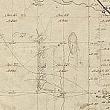
Plainfield-Sheridan Indian Trail, Stage and Mail Route
http://www.historygrandrapids.org/photo/638/plainfieldsheridan-indian-trai
The following essay was found in a file drawer with the Plainfield-Sheridan Indian Trail map at the Kent County Road Commission, and they have allowed it is be published here. It appears to have been written by Emory Houk around 1976 as he mentions the Centennial. Homer Burch received the Grand Rapids Historical Society's Baxter Award in 1980 for his lifelong study of the Grand River, and creating the Grand River archives housed at the Rockford Public Library. Both Burch and Houk are deceased.
The remaining visual evidences of the Plainfield-Sheridan trail are few. With the help of an individual well known in our community as a trustful historian I sought out the key evidence that could be of interest to others. Homer Burch agreed to cover a portion of the trail and I found he is literally a walking book on the history of the Grand River area.
Homer lives on N. Coit Road near the head of Grand Island. He explained, looking out across the river, that in the earlier days the Indians traveling north crossed the Grand by wading or canoe according to the season. The River at the head of Grand Island in earlier times was very shallow. After crossing the river the Indian trail ascended the bluffs to where the Blythefield Country Club is now located.
The northbound Buckboard Stage with two horses went further east to cross the Grand near the site of the present Plainfield Bridge. At this point a ferry provided the means to cross the river. The Buckboard Stage wagon was of simple construction. The wheels were relatively light carrying a long box body with a seat on the front end for the driver. This conveyance was light and fast in contrast to the famous Concord Coach which required 4 to 6 horses to operate over the rough trails.
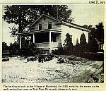
The Stage served the small village on the north side of the river called Plainfield Village with supplies and mail. The Village post office was named Austerlitz.
From the village the stage mounted the hill and traveled north, where Kuttshill Drive is now located, to the Baptist Church at the top of the hill. Here the trail continues in a northeasterly direction to Brewer Road and on to the location of the Rockford Elementary School. An early settler reported witnessing a skirmish between two Indian parties in this area east of Brewer Road.
The school is on the south side of Kroes Road, and on the north side of Kroes and east of Northland Drive is the farm of Henry Schumaker. Henry has lived on this land 69 years. He told us that the Indian Trail and Stage road angled across his land from just north of the corner of Northland Drive and Kroes Road. He could show us evidence of the Stage road at the north end of the farm. Together we investigated this evidence by hiking through cutover timber and brambles to a gently curving gully from northeast to an easterly direction. Here at the foot of the north slope of the gully was a barely discernible flat surface curving to the east. After much clambering through downed timber we came out on US 131 at a point directly west of 7370 Courtland where Courtland swings northeastward. Neither of us would have recognized the areas as the former Stage Road—too many yeasr of erosion had covered the tracks of the stage wheels.
We retraced our steps back to Henry’s home and mounting our faithful steed we headed for Courtland Drive. Where the drive turns northeastward we were again on the Stage road. Courtland descends through a low area crossing Barkley Creek which drains into the Rogue River. Homer remembers when high water on the creek made a lake here in the springtime and muskellunge were speared. These fish came up from the Grand River. Very probably the Stage required corduroy road construction to get through this area. Rising to higher ground Courtland Road curves northward. The Stage continued on northeastward to Blakely Road about where Henry Scholl’s barn now stands.
A very interesting structure is near the barn and is now being used to store farm implements. This small building was constructed in 1846 and is one of the earliest buildings to be lathed and plastered inside and the wooden blackboard can still be seen on the end wall. The small school building cared for 40 children when Homer’s mother attended classes here about 1881. On the east side of Blakley Road across from the Scholl’s house is the home of John Cavanaugh. In the rear yard is a knoll and a large walnut tree. A Stage house stood on the knoll facing the trail in those early years. This house had a room for horseback transport to Lapham (Rockford). The Stage passed just to the south of the walnut tree and continued on northeastward.
We returned north on Blakley then east on Kies Road to where Kies turns northeastward to again pick up the trail route. Here at the turn in the road on the south side of Kies Road is the home of L. Millet. This farm home is the original structure used as the Stage tavern. It was built facing the trail with a long porch on the trail side, leaving the house askew to Kies Road. When the road was put through a porch was added to the road side. There are three large maple trees in the rear of the home and they too line up to the northeast. It seems obvious that the trees were planted to shade the activity that occurred at the Tavern stop. The Stage undoubtedly passed under the maples or drew up there to unload and load. It is at this point that Kies Road again angles northeast and is the trail route to the crossing of Rum Creek in the valley. The creek crossing is where Chief Wabasis was ambushed and murdered for the gold he was supposedly carrying. Today there is a pond on each side of the road.
The house on Kies Road is the only, easily visible evidence of the Stage trail route. The evidence on Henry Schumaker’s land is hard to see and difficult to appraise, but Henry’s tenure on the land lends credence to the fact that the place pointed out in the wooded gully was actually the Stage route across his land. It is hard to realize that in the days of Stage travel the landscape was not what we see today. In one authentic description by an early tavern owner the canopy of trees was complete, little sun ever reached the earth except in the low bogs where only grass would grow.
This historical trail route may be on interest to groups of Scouts in the celebration of the Centennial.
Emory Houk, Scouter
Homer Burch, Scouter
This Indian and Stage Trail route map can be used for hikes and instruction in the early history of Kent County. Hikes would use the roadways and whenever possible talk to the private land owners, and, of course, seek permission to enter or cross private property for today all property is privately owned.
 facebook