
Surveying the Land
by GRHC
published: December 1st, 2006
The Northwest Ordinance, passed by Congress in 1787, established among other things a new method of surveying the land and dividing it into small parcels. It was called "Township and Range." Michigan, with five other states, saw this new plan put into action as surveyors charted the wilderness. When the government surveyors arrived in 1831 they came upon a small community on the shores of the Grand River: Baptist and Roman Catholic Missions serving the Indians on the west bank, and Louis Campau's trading post on the east bank. These indications of settlement are shown on the first survey maps. (Find more information to your right in Related Items)
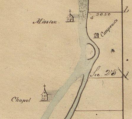
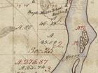
Lucius Lyon, who would become a resident of early Grand Rapids, surveyed Township 7 North, Range 12 West, in April of 1831. This map shows a small portion of section 25 on the east side of the Grand River where the Campeaus (sic) are noted. When Louis Campau purchased the patent in 1833 his seventy-two acres ran from Bridge St. (now Michigan) on the north, Division on the east, Fulton on the south, and the river on the west. The west side of the river occupied by two Indian missions was called the mission reserve, and both the Baptist Mission and Roman Catholic chapel are illustrated.
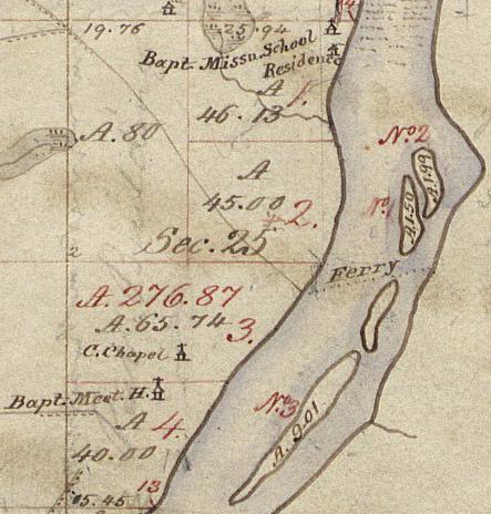
In June of 1837, shortly after Michigan became a state, the area was surveyed again. This map shows a similar area to the one above, but with more detail. The Baptist Mission School, Residence and Baptist Meeting House, situated on the west side of the Grand River, occupied 160 acres. The Mission, manned by Rev. Leonard Slater, encompassed an area from Bridge St. on the north to south of Fulton. Father Frederic Baraga erected a frame building for the Roman Catholic chapel also on the west side of the river. The dotted line shows the location of the ferry which connects with the Indian trail coming from the west, and islands #1 and #2 are more delineated than on the 1831 map. In 1841 Louis Campau received the patent on those two islands, and island #3 went to Richard Godfroy.
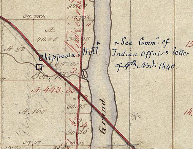
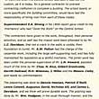
This portion of map shows the west side of the Grand River north of the rapids where the government built the Chippewa Mill. Located about one and a quarter miles north of Bridge St., the mill served the mission. The red lines mark the Grand Rapids and Indiana Railroad running north and south and the Detroit and Milwaukee Railroad running from northwest to southeast. Neither of these railroads existed in 1837 so these markings were added later. The GR &IN Railroad began in 1867 and the Det. & Mil. Railroad in 1858.
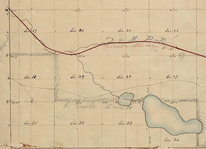
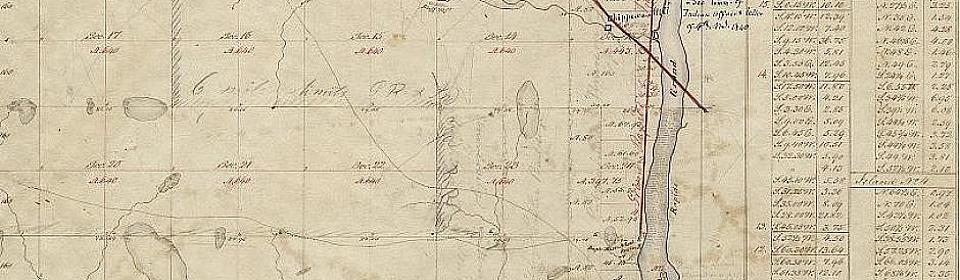
This portion of the 1831 survey map records land to the east of that shown in the above maps. This area is Township 7 north, Range 11 West, and the two bodies of water in the lower right are Fisk and Reeds Lake. Sections 19 and 30 on the left became part of the original city of Grand Rapids. The route of the Detroit and Milwaukee Railroad has been added to this map, also, and picks up the RR line at the left from the prior map.
The land rush is on! Glance at the Past tells of West Michigan's first claim office.
 facebook

Bibliography
Books available at the GR History and Special Collections, Grand Rapids Public Library
- Baxter, Albert. History of the City of Grand Rapids, Michigan (With an appendix--History of Lowell, Michigan). New York, Grand Rapids: Munsell & company, 1891.
- Belknap, Charles E. The Yesterdays of Grand Rapids. Grand Rapids: The Dean Hicks Co., 1922.
- Karrow, Robert W., Editor. Checklist of Printed Maps of the Middle West to 1900, Michigan, Vol 5. Boston: G. K. Hall & Co., 1981
- Rohrbough, Malcolm J. The Land Office Business: The Settlement and Administration of American Public Lands, 1789-1837. Oxford Univ. Press, 1968
- Kent County Plat Map Compendium, 1855-1992.