
Kent County Steam Distribution System
Kent County Dept. of Public Works - 1986
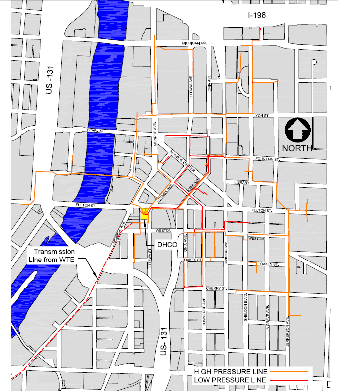
The detailed map shows the extent of the steam distribution system in downtown Grand Rapids. It serves buildings as far north as Michigan St., east to Jefferson Ave., south to Cherry St., and west to Campau Ave. except for the line that crosses the Grand River at the Blue Bridge to service the Grand Rapids Public Museum and Grand Valley State University's downtown campus. The red dotted line that follows Market Ave. and is labeled 'Transmission line from WTE' is no longer in use. The District Heating and Cooling Operation (DHCO) plant at the corner of E. Fulton and Market is marked in yellow. The high-pressure lines are indicated in yellow and the low-pressure lines in red. The Grand River, in bright blue, runs north to south. I-196 and US-131 are indicated on the map.
Subjects
Full Details
| Title | Kent County Steam Distribution System |
|---|---|
| Creator | Kent County Dept. of Public Works |
| Date | 1986 |
| Format | Digital map |
| Notes | Title from document. WTE (Waste to Energy) transmission line ran out Market to the Waste Treatment plant where refuse was burned to create steam, which was transmitted through the pipeline to supplement the Fulton St. heating plant during the winter months. |
| Location In Photo | Grand Rapids, MI |
| Collection | Kent County Dept. of Public Works |
| Rights | Reproduction and copyright information regarding this image is available from the Kent County Dept. of Public Works. |