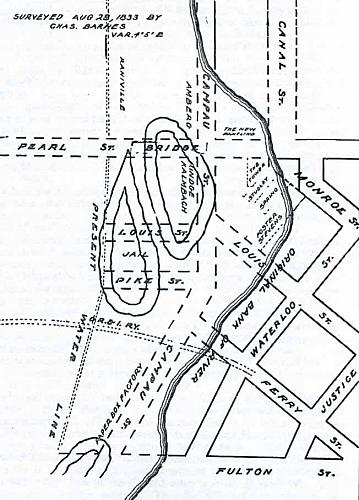
Grand River Map, Before and After
1926
The map shows the old banks of the river and the location of islands Nos. 1 and 2. The dotted lines show the area as of 1926. Campau Avenue is almost wholly on the old river bed and the jail on Island No. 2. Waterloo Street became Market Avenue. The map makes clear the double turn connecting old Monroe Ave. and Canal St. before Campau Square came into existance. Buildings that occupied the triangle betwee Monroe and Canal were torn down in 1873. Ferry St. received its name because in the early days there was a ferry across the river at its western end.
Subjects
Full Details
| Title | Grand River Map, Before and After |
|---|---|
| Date | 1926 |
| Format | Map |
| Notes | The map is from A Citizens' History of Grand Rapids by William J. Etten. Published in 1926 by the A.P. Johnson Co. for the Campau Centennial Committee. The original survey map was drawn by Chas. Barnes, Aug. 28, 1833. |
| Location In Photo | Grand Rapids, MI |
| Collection | Private |

