
1831 Survey by Lucius Lyon
US Government - 1831
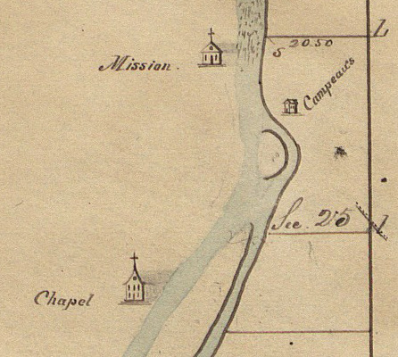
Section 25 of the of the April 1831 government survey map of Township 7 North, Range 12 West by Deputy Surveyor Lucius Lyon. On the west side of the Grand River a mission (Baptist) at the south end of the rapids and chapel (Roman Catholic) are depicted, and on the right a house indicating the Campeaus (sic).
Subjects
Full Details
| Title | 1831 Survey by Lucius Lyon |
|---|---|
| Creator | US Government |
| Date | 1831 |
| Format | Digital image of map downloaded from the Bureau of Land Management web site. |
| Notes | Title by cataloger. Section 25 which became Walker Township extends to the west of the river, but nothing is shown on the 1831 map. The 1837 survey map does show the sections. Lucius Lyon was a patentee of land in both sections 24 and 25 in November of 1833. |