Roads and Streets
GRHC - March 31st, 2014
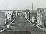
The early roads into the village of Grand Rapids were along Indian trails, and the influence of these trails on the city can still be seen today.
Transcript
The early roads into the village of Grand Rapids were along Indian trails, and the influence of these trails on the city’s overall street pattern can still be clearly seen in streets such as Monroe in downtown Grand Rapids and Stocking on the West Side. By 1850, when the village became a city, the street arrangement became more systematic. Streets developed in more or less square blocks, except where the Indian trails had already become fixed by traffic habits. With the development of the Ottawa Hills area in the 1920’s streets began to wind for a more attractive landscape effect.
The city had begun on the lumpy and soggy east side of the river, slighting, if not ignoring, the flatter west side. The enormity of physical labor in the grading, cutting, and filling can hardly be conceived in the light of later earth moving machinery.
The grade on the lower end of Canal Street was raised nearly fifteen feet. Where the old Union railway depot stood on Ionia Avenue, opposite the end of Oakes Street, the level was raised from two to ten feet. There was a high hump near Division Avenue south of Fulton Street that was cut down. As the city spread eastward, cuts had to be made through the bank to the east to extend Michigan, Lyon, Fountain, and Fulton Streets. Successive cuts in Lyon Street left large, handsome homes isolated high above the surrounding landscape.
Full Details
| Title | Roads and Streets |
|---|---|
| Creator | GRHC |
| Keywords | WYCE; radio; Grand Rapids; Historical Commission; history; Indian trails; streets |
| Duration | 2:08 |
| Pubdate String | March 31st, 2014 |
 facebook