Louis Campau and Other Early Land Patentees

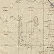
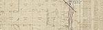
Louis Campau arrived in the area in November of 1826 with a government license to engage in Indian trade, and built his log house which is considered to be the first inhabitation of the white man. Rix Robinson preceded Campau by five years, but took over the trading post of Madame LaFramboise located on the Grand River in Ada Township, section 28, Township 7 North, Range 10 West (28 T7N R10W). Robinson's cabin shows on the first survey map of Ada Township.
In addition to being the first white man to establish residence here, Louis Campau was also the first to receive a land patent in section 25, Township 7 North, Range 12 West of Kent County on October 10, 1833. He registered at the White Pigeon Prairie land office in St. Joseph County. His land was bounded by Bridge St. (now Michigan) on the north, Division on the East, Fulton on the south, and the river on the west. However, others were right behind him. By November 5 of the same year Lucius Lyon, Eurotas Hastings, and Henry Ellsworth had received their land patents. By December 2nd Samuel Dexter and Tousant Campbell joined the early land owners. A year later Daniel Coit, Joel Guild, Walter Sprague, and Abram Wadsworth had made the trip to the White Pigeon Prairie land office.
By 1836 a land office had opened at the town of Bronson which would become Kalamazoo, and another in opened in Ionia the same year. In 1841 when Louis Campau applied for the rights to the #1 and #2 islands in the Grand River he registered his claim with the Ionia land office. The same date found Richard Godfroy applying for the #3 island in the river.
All of the above grants were in one of the four sections that would become the first incorporated city of Grand Rapids:
- section 24, Township 7 North, Range 12 West
- section 25, Township 7 North, Range 12 West
- section 19, Township 7 North, Range 11 West
- section 30, Township 7 North, Range 11 West
For the full maps of Kent County surveys go to Bureau of Land Management
- Click on Search Surveys
- Enter Kent for the county
- Select a survey to view
- When the survey information appears click on the Plat Image tab
You can use the zoom indicator located in the lower left corner and the arrows on the four sides to navigate around the image.
 facebook