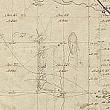
Public Land Survey System
The Northwest Ordinance, passed by Congress in 1787, provided for the government of land called the Northwest Territories—the area north of the Ohio River, west of Pennsylvania, and east of the Mississippi River—or the land that would become the states of Ohio, Indiana, Michigan, Illinois, Wisconsin, and a small part of Minnesota.
A new method was proposed and adopted to survey this vast new territory, and was eventually extended to most of the continental United States west of the Mississippi River. The United States Public Land Survey (USPLS) is a system that divides land into smaller parcels based on the English system using acres and miles as the basic units of measurement. This system is sometimes referred to as “Township and Range” while the system used in most of the original thirteen colonies is called “Metes and Bounds.”
Kent County was surveyed using the township and range method in 1831, and then again in 1837 when Michigan became a state. When the surveying of the territory began, the earliest surveys were of counties in the south and east including Wayne and Monroe (1818), and Washtenaw and Lenawee (1819). It appears the surveyors worked north and west across the land as Ingham County was first surveyed in 1821 and Ionia in 1827.
 facebook